

Reading through one of my fellow bloggers pages (thankyou Stephen) reminded me of a couple of old Japanese maps I have saved on my hard drive. I love old maps and I remember studying a few maps while doing my history major at university. Lets have a look.
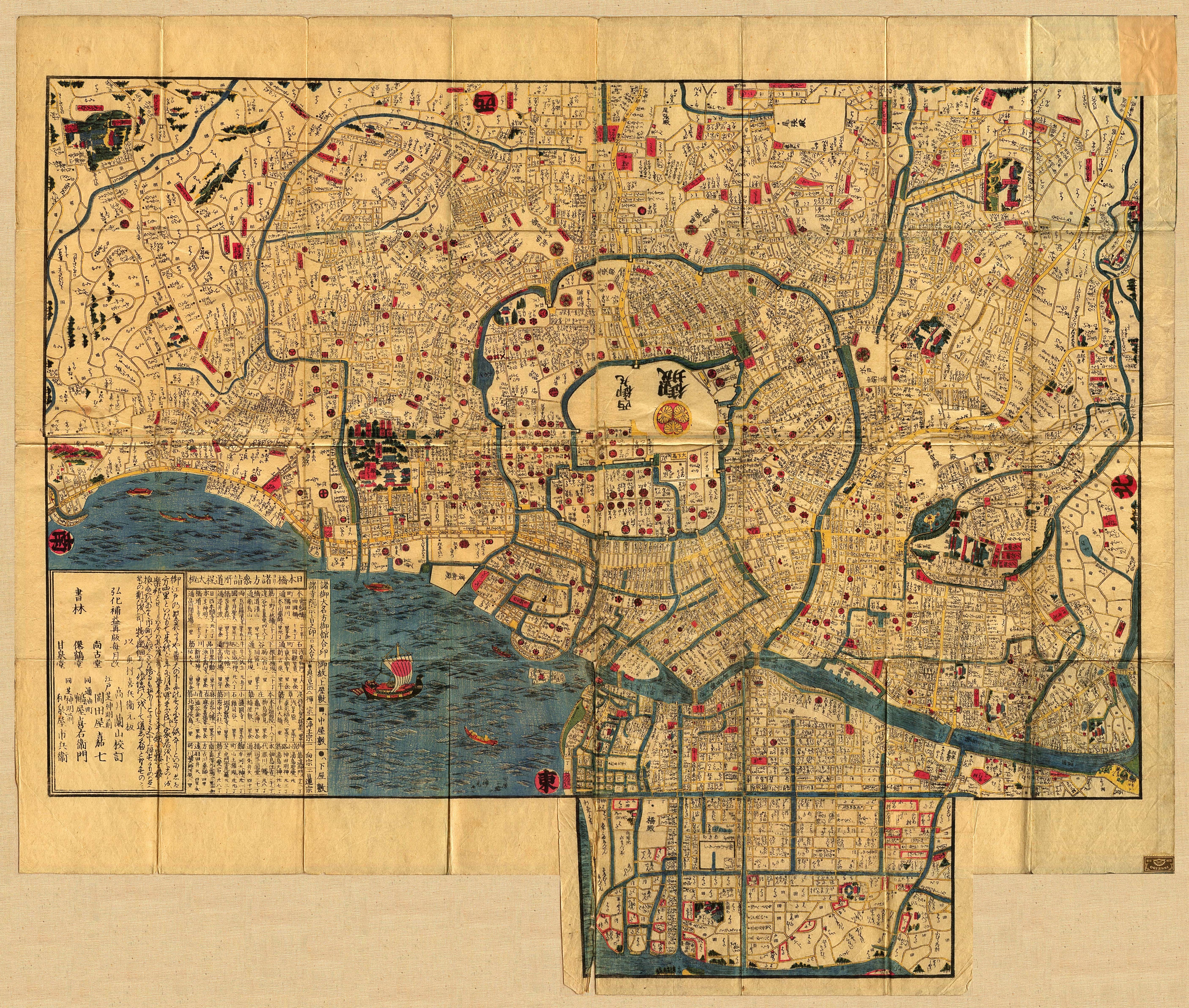
A map of Edo in the 1840s, at the end of Tokugawa rule in Japan. The map shows Edo castle in the centre of the city with the Tokugawa retainers residences surrounding the castle. The higher ranked retainers had the privilege of living close to the Shogun. Their homes were also much larger than the lower ranked retainers who lived further away from the castle. Merchants and fishermen established their warehouses and homes around the edges of the bay.
Prior to the Tokugawa period Edo was only a small fishing village. It was never seriously settled before the Tokugawa period. The Edo region suffered from heavy rain in the wet season causing severe flooding on the marshlands surrounding the bay, it also suffered from earthquakes and tsunamis. Edo, however was rapidly populated after Ieyasu Tokugawa became Shogun in 1603. The Tokugawa central government forced Daimyo (regional lords) to live in Edo, a system known as sankin kotai. The system was initially used by the government to keep an eye on the regional Daimyo and to ensure they were not able to gather local support to uprise against the Shogun. Regional Daimyo, their families and entourage settled in Edo. Many of them in the end rarely saw their homelands and after a generation or two the grandsons of those lords never left Edo. Generations of regional Daimyo continued to represent their homelands but in actual fact have never seen them.
Edo evolved into a city of upper class nobility with the Edo castle as its center. By the middle on the 18th century Edo grew to have a population of about one million. In 1868 after the defeat and collapse of the Tokugawa bakufu, Edo was renamed to Tokyo.

Sorry this map didn’t copy so well. Kyoto in 1696.
First thing we see from this map is the size of Kyoto during the early Tokugawa period. The city is surrounded by hills, mountains and is serviced by and important river (Shirakawa river) which separates east from west. You will also notice the large castle complex area on the western side of Kyoto which is Nijo Castle, headquarters of the Tokugawa bakufu in Kyoto.
After the Tokugawa bakufu took control of Japan in 1603 Kyoto’s role in Japanese history somewhat changed. Kyoto became the spiritual and cultural city of Japan. For those of you who have visited Kyoto I’m sure you would have noticed the large number of temples and shrines that surround the city. Gion district just on the east side of the Shirakawa river is famous for guesthouses, theatres, teahouses and restaurants. The Gion district is still accommodating travellers who wish to do business in Kyoto or for the thousands of visitors who want to visit the thousand of shrines and temples as it has done so for hundreds of years.

You must be logged in to post a comment.